Basic map reading and navigation is one of the key skills which all players should possess when playing Arma. This is skill which will be used almost every time you play and it is therefore highly important to gain a good understanding of at least how to read the map, interpret directions and translate what you see on the map into world that you see in front of you in game.
Grid References[]
In the map reading part you saw that the map is divided in grids, the sizes of which can vary. The horizontal lines which divide the map are known as 'Eastings' and the vertical lines are known as 'Northings'. All of the Eastings and Northings are labelled with numbers that can be seen on all 4 edges of the map. These numbers can help you determine how big the grid is in terms of 'real world' distance but they also have another use. By combining the numbers of the Eastings and Northings we can create what is known as a 'Grid Reference'. This number, when interpreted properly, corresponds to a specific grid on the map, allowing you to accurately describe a location on the map via its grid reference, which will be a 4 to 8 digit number.
NOTE: On the Arma 2 map, the grids themselves are labelled at the midpoint of the horizontal and vertical axis of each grid, rather than the Easting and Northing lines themselves being labelled, meaning that grid referencing is slightly simpler, however in Arma 3 it is the lines themselves that are labelled.
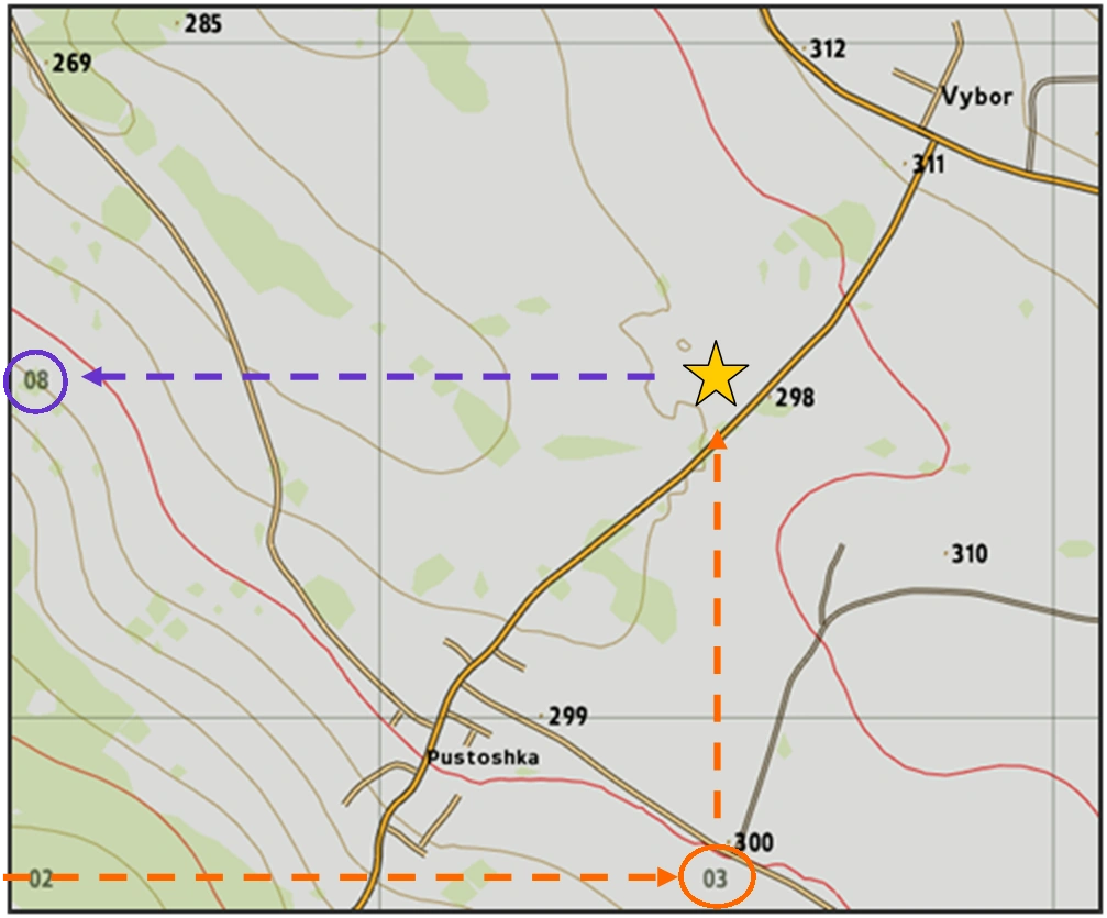
The process of obtaining a grid reference is relatively straight forward and the simplest form of grid reference you can give is a 4 digit grid reference. The 4 digit reference is made up of 2 sets of 2 digit numbers, the first number is taken from the Northing and is obtained by reading along the horizontal axis (along the corridor) until you are in line with the relevant grid on the map. The second number is taken from the Easting and is obtained by reading along the vertical axis (up the stairs) until you are in line with the relevant grid on the map. This method is sometimes known as 'Along the corridor and up the stairs' - You first read along the horizontal axis (shown with an orange dotted line above) until in line with the relevant grid/ object to give you the frist number, in this case 03. You then read along the vertical axis to find the second number in line with the relevant grid/ object (shown with a purple dotted line), in this case 08. You then combine the two numbers, with the horizontal number coming first to give a 4 digit number, in this case 03 + 08 = 0308. This is a 4 digit grid reference so it corresponds to an area 1km x 1km on the map.
In order to achieve a higher degree of precision when describing positions using grid references, for example if we wanted to describe the specific location of a town rather than simply the 1km square it was located in, we need to break the grid down into smaller sub-grids and therefore use more digits in our grid references. When at a higher level of zoom on the map the grids will be broken down into 100m x 100m grid square, each labelled with a 3 digit number. The method for obtaining a grid reference is the exact same, the only difference is that the grid reference is now comprised of two 3 digit numbers, giving a 6 digit grid reference overall. A 6 digit reference refers to a 100m x 100m square area on the map.
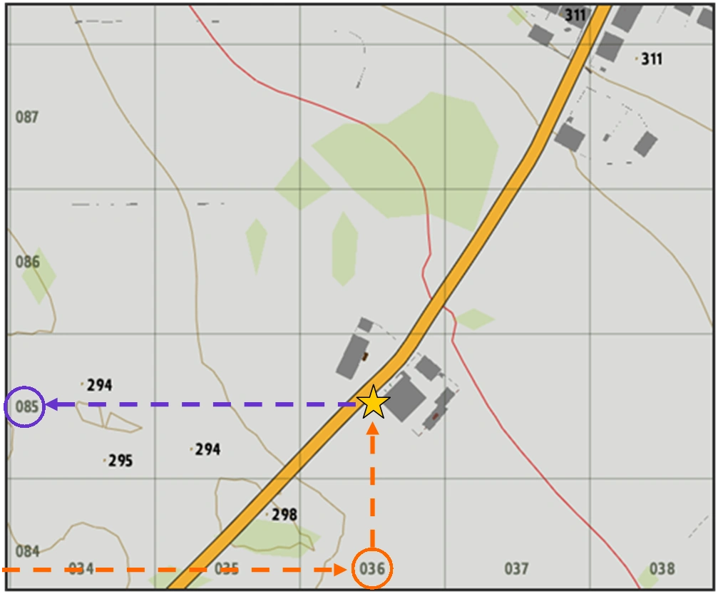
If I wanted to give the exact location of the farm complex, marked here with a yellow star in the second diagram and located roughly half-way between Vybor and Pustoska, the two towns visible on the first diagram I would use a 6 figure grid reference to give a more accurate indication of where the farm lay within the grid 0308. Again, the first half of the reference is obtained by reading along the horizontal axis, in this case the value is 036, highlighted in orange. I then read up the vertical axis to find the value for this grid, in this case 085, highlighted in purple. Notice that the first two digits of each number are the same as those in the 4 figure reference and a third number has simply been added to each. This shows that the grid 0308 has been divided up into 10 smaller grids, each labelled from 0 - 9. We can now combine these two 3 digit numbers to give a 6 figure grid reference of 036085. This gives a much better indication of where the farm lies than if we simply gave a 4 figure reference of 0308, as the 6 figure reference refers to a 100m x 100m square area, rather than a 1km x 1km area.
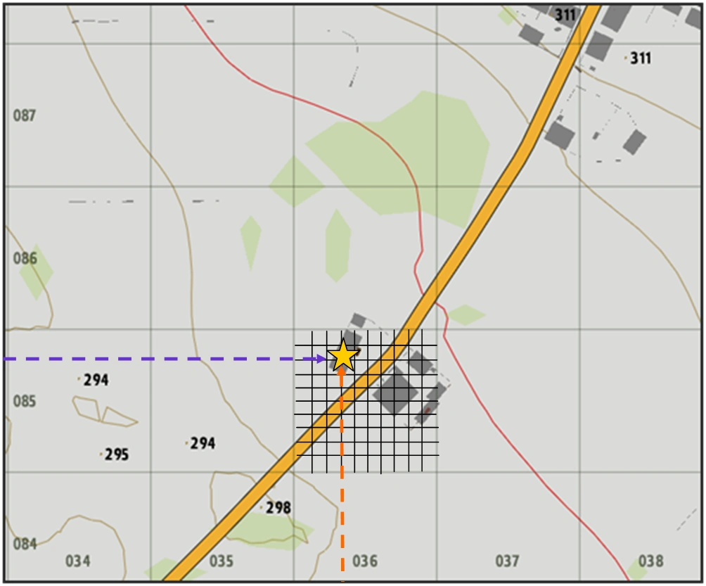
We have now covered two different types of grid references that you can use in combination with the map to either describe a location to another or to find a location on the map after receiving a grid reference from another. The 6 digit grid reference gives a good degree of accuracy on the map by providing a reference to a 100m x 100m square area, however sometimes and even greater degree of acuracy is required. In this case we must sub-divide the grid once again in order to allow us to refer to a 10m x 10m square area, therefore requiring us to give an 8 figure grid reference. The 8 figure reference is a combination of two 4 digit numbers and is obtained in the same way as the 4 and 6 figure references, however the map's number labelling does not go into sufficient depth to give us 4 digit labels on grids. Instead, we must take the 3 digit references and then use our own eye to estimate the 4th digit for each number by sub-dividing the 100m x 100m square grid into 10 smaller sections along the vertical and horizontal axis in our heads. In the 3rd diagram I am attempting to obtain a grid reference for the farm building north of the main road in grid 036085, marked with a yellow star. I have sub-divided grid 036085 a further 10 times along both axes in order to estimate where exactly within grid 036085 the building lies
. Again I read along the horizontal axis first to obtain the first half of my grid reference, and I can see that the building is roughly 3 tenths (3/10) of the way along the horizontal axis of grid square 036085. Therefore, I simple take the grid label 036 and add a 3 to the end (3 because the building is 3 10ths of the way along the horizontal) as the 4th digit, giving me the first half of my reference as 0363. I now repeat this process for the second half of my reference by reading up the vertical axis, where I can see that the building is roughly 8 tenths (8/10) of the way along the vertical axis of the square. I therefore add 8 to the end of the grid label 085 as the 4th digit to give me the second half of my reference as 0858. I can now combine my two 4 digit numbers taken from the horizontal and vertical axes to give me my 8 figure grid reference of 03630858. This 8 figure reference refers to a 10m x 10m square area within the grid square 036085, showing a much higher degree of accuracy and allowing others to much more effectively pinpoint this location on their maps.
Generally the 6 figure reference provides adequate detail for map reading, the 8 figure grid reference is generally used for marking enemy positions on the map or for calling in support such as airstrikes, artillery or supply drops, where a high degree of accuracy is required to ensure that the support is on target.